
Portal:Kent/Sandbox
DesktopMobile
Test of: Transclude files as random slideshow/sandbox
-
 The White Cliffs of Dover (from Kent)
 -
 An early mention of Kent in the Anglo-Saxon Chronicle between 11th and 12th centuries (from Kent)
 -
 Geological cross-section of Kent, showing how it relates to major towns (from Kent)
 -

-
-
-

-

-
 View of the White Cliffs of Dover from France (from Kent)
 -
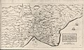
 Hand-drawn map of Kent, Sussex, Surrey and Middlesex from 1575. (from Kent)
 -
 A map of Romney Marsh "The history of imbanking and drayning" by William Dugdale (1662). (from Kent)
 -
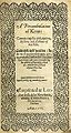 Title page of William Lambarde's Perambulation of Kent (completed in 1570 and published in 1576), a historical description of Kent and the first published county history (from Kent)
 -
 Canterbury Cathedral (from Kent)
 -
 The coat of arms of Kent County Council (from Kent)
 -


Apr2006.jpg)


.jpg)


Test of: Transclude linked excerpts as random slideshow/sandbox
-
 South East England is one of the nine official regions of England in the United Kingdom at the first level of ITL for statistical purposes. It consists of the counties of Buckinghamshire, East Sussex, Hampshire, the Isle of Wight, Kent, Oxfordshire, Berkshire, Surrey and West Sussex. Major towns and cities in the region include Brighton and Hove, Canterbury, Milton Keynes, Southampton, Portsmouth, Slough, Reading and Oxford. (Full article...)
 -
Holcombe Hockey Club is a field hockey club based in Rochester, Kent, England. The home ground is located at Holcombe Park, where there is a water-based pitch, a sand-based pitch and a clubhouse. The club was formed in 1999/2000 from a merger of clubs in the area. (Full article...)
-
Gravesham (/ˈɡreɪvʃəm/ GRAYV-shəm) is a local government district with borough status in north-west Kent, England. The council is based in its largest town of Gravesend. The borough is indirectly named after Gravesend, using the form of the town's name as it appeared in the Domesday Book of 1086. The district also contains Northfleet and a number of villages and surrounding rural areas. (Full article...)
-
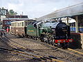
Ashford International railway station is a National Rail station in Ashford, Kent, England. It connects several railway lines, including High Speed 1 and the South Eastern Main Line. Services are operated by Southeastern and Southern. (Full article...)
-
British Railways (BR), which from 1965 traded as British Rail, was a state-owned company that operated most rail transport in Great Britain from 1948 to 1997. Originally a trading brand of the Railway Executive of the British Transport Commission, it became an independent statutory corporation in January 1963, when it was formally renamed the British Railways Board. (Full article...)
-
Blean is a village and civil parish in the Canterbury district of Kent, England. The civil parish is large and is mostly woodland, much of which is ancient woodland. The developed village within the parish is scattered along the road between Canterbury and Whitstable, in the middle of the Forest of Blean. The parish of St Cosmus and St Damian in the Blean was renamed "Blean" on 1 April 2019. (Full article...)
-
Tonbridge and Malling is a local government district with borough status in Kent, England. The council is based at Kings Hill. The borough also includes the towns of Tonbridge and Snodland along with numerous villages including Aylesford, West Malling and surrounding rural areas. (Full article...)
-
The Darent is a Kentish tributary of the River Thames and takes the waters of the River Cray as a tributary in the tidal portion of the Darent near Crayford. 'Darenth' is frequently found as the spelling of the river's name in older books and maps, Bartholomew's Canals and River of England being one example. Bartholomew's Gazetteer (1954) demonstrates that Darent means "clear water", a result of it springing from and running through chalk. The purity of the water was a major factor in the development of paper and pharmaceuticals in the area. (Full article...)
-
Manston is a village and civil parish in the Thanet district of Kent, England. The village is situated one mile northwest of Ramsgate. The parish includes four hamlets and the former Manston Airport. (Full article...)
-
Invicta is a Latin word meaning invincible, undefeated, or unconquered. It has been used in mottoes like Roma invicta (Latin for "Unconquered Rome"), and it is the motto of the county of Kent, England. (Full article...)
-
Thomas Sidney Cooper CVO RA (26 September 1803 – 7 February 1902) was an English landscape painter from Canterbury, noted for his images of cattle and farm animals. (Full article...)
-
The Kent Women cricket team is the women's representative cricket team for the English county of Kent. They play their home matches at County Cricket Ground, Beckenham, as well as the St Lawrence Ground and Polo Farm, both in Canterbury. They are captained by Megan Belt and are coached by David Hathrill. They are the most successful side in both the Women's County Championship and Women's Twenty20 Cup, with 8 and 3 titles respectively. They are partnered with the regional side South East Stars. (Full article...)
-
South East England is one of the nine official regions of England in the United Kingdom at the first level of ITL for statistical purposes. It consists of the counties of Buckinghamshire, East Sussex, Hampshire, the Isle of Wight, Kent, Oxfordshire, Berkshire, Surrey and West Sussex. Major towns and cities in the region include Brighton and Hove, Canterbury, Milton Keynes, Southampton, Portsmouth, Slough, Reading and Oxford. (Full article...)
-
Clay is a type of fine-grained natural soil material containing clay minerals (hydrous aluminium phyllosilicates, e.g. kaolinite, Al2Si2O5(OH)4). Most pure clay minerals are white or light-coloured, but natural clays show a variety of colours from impurities, such as a reddish or brownish colour from small amounts of iron oxide. (Full article...)
-
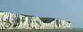
The White Cliffs of Dover are the region of English coastline facing the Strait of Dover and France. The cliff face, which reaches a height of 350 feet (110 m), owes its striking appearance to its composition of chalk accented by streaks of black flint, deposited during the Late Cretaceous. The cliffs, on both sides of the town of Dover in Kent, stretch for eight miles (13 km). The White Cliffs of Dover form part of the North Downs. A section of coastline encompassing the cliffs was purchased by the National Trust in 2016. (Full article...)
-
Sandown Castle was an artillery fort constructed by Henry VIII in Sandown, Kent, between 1539 and 1540. It formed part of the King's Device programme to protect against invasion from France and the Holy Roman Empire, and defended the strategically important Downs anchorage off the English coast. (Full article...)
-
The Kent Coalfield is a coalfield in the eastern part of the English county of Kent. The Coalfields Trust defines the Kent Coalfield as the wards of Barham Downs and Marshside in the Canterbury district, and the wards of Aylesham, Eastry, Eythorne & Shepherdswell, Middle Deal & Sholden, Mill Hill and North Deal in the Dover district. (Full article...)
-
Swanley is a town and civil parish in the Sevenoaks District of Kent, England, 16 miles (26 km) southeast of central London, adjacent to the Greater London boundary and within the M25 motorway periphery. The population at the 2021 census was 17,826. (Full article...)
-
Ebbsfleet International railway station is in Ebbsfleet Valley, Kent, 10 miles (16 kilometres) east of London, England, near Dartford and the Bluewater shopping centre to the west and Gravesend to the east. The station, part of the Thames Gateway urban regeneration project, is on the High Speed 1 (HS1) rail line, 400 metres (1,300 feet) south-west of Northfleet railway station, off the A2 trunk road, 5 mi (8.0 km) from its junction with the M25 motorway. It served as a primary park-and-rail service for the London 2012 Olympics. (Full article...)
-
Swanley is a town and civil parish in the Sevenoaks District of Kent, England, 16 miles (26 km) southeast of central London, adjacent to the Greater London boundary and within the M25 motorway periphery. The population at the 2021 census was 17,826. (Full article...)
-
Hampshire (/ˈhæmpʃər/, /-ʃɪər/ ; abbreviated to Hants.) is a ceremonial county in South East England. It is bordered by Berkshire to the north, Surrey and West Sussex to the east, the Isle of Wight across the Solent to the south, Dorset to the west, and Wiltshire to the north-west. The cities of Portsmouth and Southampton are the largest settlements and the county town is the city of Winchester. (Full article...)
-
The Lower Greensand Group is a geological unit present across large areas of Southern England. It was deposited during the Aptian and Albian stages of the Early Cretaceous. It predominantly consists of sandstone and unconsolidated sand that were deposited in shallow marine conditions. (Full article...)
-
Royal Tunbridge Wells is a town in Kent, England, 30 miles (50 kilometres) southeast of central London. It lies close to the border with East Sussex on the northern edge of the High Weald, whose sandstone geology is exemplified by the rock formation High Rocks. The town was a spa in the Restoration and a fashionable resort in the mid-1700s under Beau Nash when the Pantiles, and its chalybeate spring, attracted visitors who wished to take the waters. Though its popularity as a spa town waned with the advent of sea bathing, the town still derives much of its income from tourism. (Full article...)
-
Papermaking is the manufacture of paper and cardboard, which are used widely for printing, writing, and packaging, among many other purposes. Today almost all paper is made using industrial machinery, while handmade paper survives as a specialized craft and a medium for artistic expression. (Full article...)
