
File:Ifpo 22985 Syrie, gouvernorat de Lattaquié, district de Lattaquié, Minet el-Beida, vue aérienne verticale (cropped).jpg

Size of this preview: 800 × 571 pixels. Other resolutions: 320 × 229 pixels | 640 × 457 pixels | 1,024 × 731 pixels | 1,280 × 914 pixels | 1,438 × 1,027 pixels.
Original file (1,438 × 1,027 pixels, file size: 377 KB, MIME type: image/jpeg)
| This is a file from the Wikimedia Commons. Information from its description page there is shown below. Commons is a freely licensed media file repository. You can help. |
| Photographer |
|
|||||||||||
| Description |
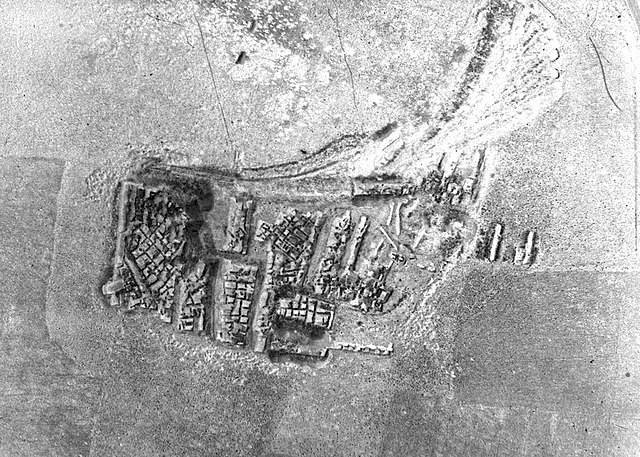
Français : Syrie, gouvernorat de Lattaquié, district de Lattaquié, Minet el-Beida, vue aérienne verticale |
|||||||||||
| Depicted place | Minet el-Beida | |||||||||||
| Date |
Taken on 23 May 1933 18 February 2020, 18:22:38 (upload date) |
|||||||||||
| Medium | gelatin silver print on sheet film | |||||||||||
| Dimensions | height: 18 cm (7 in); width: 24 cm (9.4 in) | |||||||||||
| Collection |
|
|||||||||||
| Accession number |
hal-02483716 Ifpo-22985 |
|||||||||||
| Object history | French army | |||||||||||
| Credit line |
Français : Institut français du Proche-Orient (Ifpo) ; ALIPH – Alliance internationale pour la protection du patrimoine dans les zones en conflit |
|||||||||||
| Source |
https://hal.archives-ouvertes.fr/hal-02483716 https://hal.archives-ouvertes.fr/hal-02483716/document |
|||||||||||
| Permission (Reusing this file) |
|
|||||||||||
| Other versions | ||||||||||||
| Mots-clés | Français : Vue aérienne,Archéologie,Al-mīnā al-bayḍā,Le Port blanc,Mahadou,Syrie,Minet el-Beida,Ugarit,Ougarit,Photographie aérienne,Gouvernorat de Lattaquié,Photographie aérienne verticale,District de Lattaquié |
|||||||||||

.jpg)
| Camera location | | View this and other nearby images on: OpenStreetMap |
|---|
.jpg¶ms=035.607689_N_0035.769008_E_globe:Earth_type:camera__&language=en)
File history
Click on a date/time to view the file as it appeared at that time.
| Date/Time | Thumbnail | Dimensions | User | Comment | |
|---|---|---|---|---|---|
| current | 16:17, 3 May 2021 | | 1,438 × 1,027 (377 KB) | Don-vip | increase contrast |
| 16:15, 3 May 2021 |  | 1,438 × 1,027 (230 KB) | Don-vip | File:Ifpo 22985 Syrie, gouvernorat de Lattaquié, district de Lattaquié, Minet el-Beida, vue aérienne verticale.jpg cropped 29 % horizontally, 29 % vertically using CropTool with lossless mode. |
File usage
The following pages on the English Wikipedia use this file (pages on other projects are not listed):
Global file usage
The following other wikis use this file:
- Usage on fr.wikipedia.org
- Usage on it.wikipedia.org
.jpg)